When schools across Tamil Nadu closed their gates on Monday, November 24, 2025, it wasn’t just a weather holiday—it was a race against time. A deep depression, born over the South Andaman Sea just 24 hours earlier, was hurtling westward with terrifying speed, threatening to explode into Cyclone Senyar within 48 hours. By midday, Tirunelveli and Tenkasi districts had declared full closures for schools and colleges. In 15 more districts—from Madurai to Thanjavur—only schools shut, while colleges stayed open. The message was clear: this wasn’t another monsoon drizzle. This was a system building toward disaster.
The Storm’s Rapid Rise
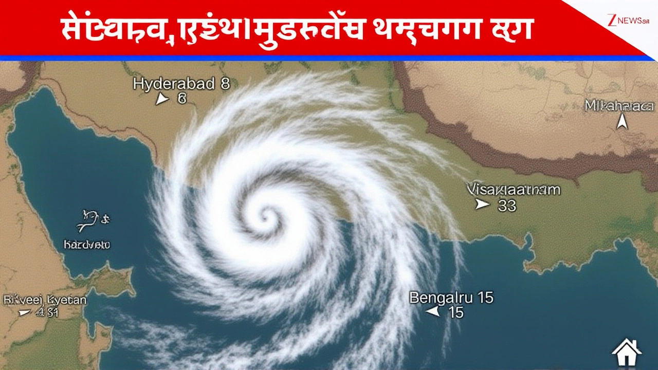
The India Meteorological Department (IMD) issued its first alert on Sunday, November 23, 2025, when a low-pressure zone formed over the Andaman Sea. By Monday morning, it had intensified into a deep depression—classified as a system with sustained winds of 55–60 kmph. Now, meteorologists warn it could become a cyclone by Tuesday, November 25, with gusts hitting 65 kmph and rainfall exceeding 200 mm in 24 hours across southern Tamil Nadu. The IMD’s forecast is unusually specific: “Very heavy rainfall likely over Tamil Nadu, Kerala, and Mahe on November 23–24,” they wrote, noting that some pockets could see over 250 mm. That’s more than the average monthly rainfall for November in many areas.
What makes this storm dangerous isn’t just its strength—it’s its timing. The Northeast monsoon, which usually tapers off by late November, is showing signs of a late, violent resurgence. “This isn’t a typical monsoon pulse,” said Dr. Arvind Menon, a climatologist at Anna University. “We’ve seen similar intensifications in 2018 and 2021, but never this fast after the monsoon’s official end.”
Who’s Affected—and How
More than 12,000 schools across 17 districts suspended classes. In Puducherry and Karaikal, even colleges shut down—a rare move. In Salem, closures were selective: only villages near the Cauvery floodplains closed schools. In Thoothukudi, where drainage systems are already overwhelmed, residents reported water rising to knee-height in low-lying neighborhoods by 9 a.m. on Monday.
The State Disaster Response Force (SDRF) was rushed to Tirunelveli and Thoothukudi by 11 a.m. Monday. Teams carried inflatable boats, medical kits, and emergency rations. District Collectors received direct orders to coordinate with local panchayats, identify high-risk zones, and prepare shelters. “We’re not waiting for the water to rise,” said Collector R. Suresh of Tirunelveli. “We’re moving people before the roads vanish.”
A Political Backdrop Amid the Rain
While the storm brewed, memories of another event lingered: Prime Minister Narendra Modi’s visit to Tamil Nadu just five days earlier, on November 19, 2025. At the South India Natural Farming Summit 2025 in Coimbatore, Modi announced the 21st tranche of PM-KISAN, releasing ₹18,000 crore to 9 crore farmers nationwide. He highlighted that 35,000 hectares of land in Tamil Nadu had transitioned to natural farming under the Central government’s initiative.
But the visit wasn’t without friction. Before Modi arrived, DMK District Secretary J. (name withheld) made remarks later shared by BJP’s Tamil Nadu president, Nainar Nagendran, that were interpreted as a death threat. The BJP called it “unacceptable,” while DMK denied any intent. The controversy, though unrelated to the weather, added a layer of tension to an already fragile political climate.

What Comes Next
By Tuesday, November 25, 2025, the IMD expects Cyclone Senyar to be officially named, with its center likely to make landfall between Nagapattinam and Cuddalore. Coastal areas are bracing for storm surges of 1.5–2 meters. Fishing boats have been ordered back to port. The National Disaster Management Authority has activated its Level 2 alert for Tamil Nadu and Kerala.
One concern that’s barely been discussed: the impact on the new natural farming fields. Over 35,000 hectares of organic land—soil enriched with cow dung, compost, and microbial inoculants—could be washed away by heavy runoff. “This isn’t just about crops,” said K. Rajesh, a farmer in Thanjavur who converted 12 acres last year. “We spent two years rebuilding our soil. One storm could undo it all.”
Historical Context: Monsoons That Broke the Pattern
Tamil Nadu’s November storms aren’t new, but their intensity is rising. In 2018, Cyclone Gaja killed over 50 people and flooded 1.2 million acres of farmland. In 2021, Cyclone Burevi caused ₹12,000 crore in damage. Both systems formed in late November—just like this one. What’s different now? Warmer Bay of Bengal waters, up 1.2°C above the 30-year average, are fueling faster intensification. “We used to have 72 hours to prepare,” said IMD senior scientist Dr. Meena Krishnan. “Now, we get 36. Sometimes less.”
The state’s response has improved since 2018—better early warnings, more SDRF teams, real-time flood mapping. But infrastructure lags. In Nagapattinam, many schools are still housed in buildings built in the 1980s, with crumbling drains. “We’re saving children today,” said Principal Latha of St. Mary’s School in Madurai. “But what about next year?”
Frequently Asked Questions
How many districts in Tamil Nadu have closed schools due to the storm?
A total of 17 districts have declared school closures. Complete shutdowns—including colleges—are in effect in Tirunelveli, Tenkasi, Puducherry, and Karaikal. An additional 15 districts have closed only schools: Madurai, Cuddalore, Nagapattinam, Karur, Virudhunagar, Ramanathapuram, Tiruchirappalli, Thiruvarur, Sivagangai, Pudukkottai, Thanjavur, Mayiladuthurai, Ariyalur, Kallakurichi, and Thoothukudi. Salem has partial closures in flood-prone zones.
What’s the difference between a deep depression and a cyclone?
A deep depression has sustained winds of 55–60 kmph and is one step below a cyclonic storm. Once winds reach 63 kmph and a closed circulation forms with sustained gales, it becomes a cyclone. The IMD predicts this system will reach that threshold by November 25, 2025, and be named Cyclone Senyar. The naming is done by the India Meteorological Department following regional protocols.
Why is the Northeast monsoon still active in late November?
Typically, the Northeast monsoon weakens after mid-November. But this year, warmer sea surface temperatures in the Bay of Bengal—up 1.2°C above average—are delaying its retreat. The deep depression formed over the South Andaman Sea, a known hotspot for late-season storms, and absorbed extra moisture. Climate scientists link this trend to broader warming patterns, making late November storms more frequent and intense.
What are the risks to farmers who adopted natural farming?
Natural farming relies on nutrient-rich, porous soil built over years using compost and microbial cultures. Heavy rainfall can wash away this topsoil, undoing two to three years of work. In Tamil Nadu alone, 35,000 hectares are under natural farming—much of it in the Cauvery delta. If runoff carries away organic matter, farmers may face lower yields next season and costly soil restoration. The state has not yet announced compensation for such losses.
What should residents in coastal areas do right now?
Stay indoors if possible. Avoid low-lying areas and riverbanks. Keep emergency kits ready: water, non-perishable food, flashlight, batteries, and important documents. Monitor IMD alerts via the official app or toll-free number 1800-599-9999. If evacuation orders are issued, leave immediately—even if the rain seems mild. Storm surges can arrive faster than expected. Do not attempt to drive through flooded roads; just 30 cm of water can sweep away a car.
Has the government provided financial aid for storm damage?
As of now, no specific relief package has been announced for this storm. However, the PM-KISAN scheme’s recent ₹18,000 crore disbursement may offer indirect support to affected farmers. The Tamil Nadu government is expected to declare a disaster zone within 48 hours, which would unlock state funds and potentially trigger central assistance under the State Disaster Response Fund. Residents are advised to document damage with photos and report to local panchayats.